|
Saturday, September 9, 2000...
Greetings from Colorado, where it's all over but the flight home. Since I won't have the usual rest-and-recovery day before returning to work, I sure hope no one needs anything done quickly or efficiently on Monday...
Began today headed southeast through one of the numerous canyons which separate Utah's central north-south strip from the outside world. Approaching Green River, I really wished I had an extra day, or even a half-day, for exploring: I was less than an hour from Arches and Canyonlands National Parks, and after driving through so much bland desert it would've been nice to be reminded what can happen when desert winds meet sandstone. Have to get back here soon...
[You'll notice that on this trip, I've identified enough places I "have to revisit soon" to fill a month-long road trip next summer. I think that's a great idea. My employer may not agree.]
Almost at the Colorado border, the terrain began to change: more vegetation and more altitude. Grand Junction, Colorado serves as the gateway to Colorado National Monument, featuring a nice loop drive along the eroded bluffs which overlook the city to the south. Downtown Grand Junction, meanwhile, features "Oh No! Another Burger Joint" and the "Wrigley Field Sports Bar," which confirms that masochism knows no geographic limit. (A few weeks ago the New York papers noted the existence of a local high school student named Elizabeth Wrigley-Field. She's never been to Chicago. Let this be a lesson: for your children's sake, if your last name is Field, don't marry anyone named Wrigley, Jacobs, Coors, Safeco, Enron, Cinergy, Comerica or Tropicana if you're planning to hyphenate. If your last name is Park, avoid people named Comiskey, Fenway or Pacific Bell. If your last name is Stadium, you have enough problems already.)
Continuing east, 6 rejoins I-70 through Glenwood Canyon, where six lanes of highway are shoehorned into the north side of a narrow canyon by building the westbound lanes almost atop the eastbound lanes, slightly further up the slope. It branches off again about 20 miles west of Vail. I knew I was entering the high-rent district when the all-you-can-eat special at a local eatery was fresh quail for $16.95/person. For once the radio was cooperating -- a local NPR outlet was playing an American Routes show highlighting music from Austin and environs. Within a 20-minute span I heard a black gospel quartet, bluesman Freddy King, the Sir Douglas Quintet, Buddy Holly and an interview with Jimmie Dale Gilmore. Then the station faded out. Oh well.
Approaching Vail proper, 6 rejoins the Interstate, crossing Vail Pass at just over two miles above sea level: 10,666'. Further ahead, where the Interstate traffic cuts through the Rockies on the Eisenhower Tunnel, 6 loops over 11,992' Loveland Pass. Stopping for a brief walk, I felt dizzy and lightheaded to the point that George W. Bush's syntax almost made sense. The well-preserved mining community of Georgetown waits at the east end of Loveland Pass.
At Idaho Springs, I was sorely tempted to drive to the summit of 14,285' Mount Evans along the highest automobile road in the United States. But by now it was after 5:00, a quick calculation showed it would take me two hours to get up and back -- and an informational sign showed that the summit temperature was a brisk 28 degrees. My wrist still bears the scar from my first visit to Mt. Evans, when I slipped on a jagged rock in the parking lot. This time I thought something quicker and safer might be in order.
First it was time to explore Idaho Springs itself, a classic riverside mining town about three miles long and three blocks wide. The Argo Gold Mine, in the hills opposite the middle of town, has been closed for years, but now offers public tours and the opportunity to pan for one's own gold in the tailings still on the premises. (Somewhere I still have the tiny fleck of gold ore which was left in my pan after I had sifted out all the lighter materials.) The "6 & 40 Motel" on the east end of town reveals that two major transcontinental routes once passed through the narrow streets of Idaho Springs.
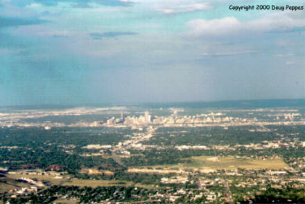
Instead of Mt. Evans, I ascended the much shorter but much more convenient Lookout Mountain, in the hills west of Denver. From the lower levels of switchback, the best views are of the sprawling Coors complex in Golden. Further up, the remarkably haze-free sky provided perfect conditions for admiring the Denver skyline, about 20 miles away, as it rose from the flat plains.
 At the summit of Lookout Mountain, appreciative Coloradans buried legendary Indian scout and Wild West promoter "Buffalo Bill" Cody. But not without a fight: after Cody died here, residents of the town he founded, Cody, Wyoming, threatened to steal the body and bring it back to Wyoming. (A small museum on the site displays photos of Colorado National Guardsmen monitoring the site to ward off possible Wyoming grave robbers.) Cody died in Colorado while visiting relatives, at a time when he was virtually broke; the museum hinted that his widow may have received some money for allowing him to be buried in Colorado.
As I descended Lookout Mountain, the sun slowly disappeared behind the Rockies. I continued on Route 6 to the junction with I-25, where I had left off in the spring, then turned south toward Colorado Springs, my mission accomplished. At the summit of Lookout Mountain, appreciative Coloradans buried legendary Indian scout and Wild West promoter "Buffalo Bill" Cody. But not without a fight: after Cody died here, residents of the town he founded, Cody, Wyoming, threatened to steal the body and bring it back to Wyoming. (A small museum on the site displays photos of Colorado National Guardsmen monitoring the site to ward off possible Wyoming grave robbers.) Cody died in Colorado while visiting relatives, at a time when he was virtually broke; the museum hinted that his widow may have received some money for allowing him to be buried in Colorado.
As I descended Lookout Mountain, the sun slowly disappeared behind the Rockies. I continued on Route 6 to the junction with I-25, where I had left off in the spring, then turned south toward Colorado Springs, my mission accomplished.
Back to NEWS FROM THE ROAD menuBack to ROADSIDEPHOTOS.COM home page
|