Early this morning I saw one of the trip's most surprising sights: my breath. Park City, Utah was about 50 degrees when I stopped there for gas. I wasn't complaining. From Park City, US 40's official western terminus -- it runs all the way to Atlantic City, NJ, ending about four miles south of the east end of US 30 -- 40 climbs into the ranchland of eastern Utah, carrying only a tiny fraction of the region's east-west traffic. I-80 to the north and I-70 to the south do most of the heavy lifting, leaving 40 for us Roadies.
 Whenever I
assemble the Route 40 photo section of my Web site, the travels
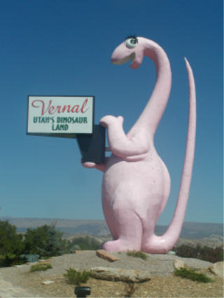
of Vernal's pink dinosaur will be well documented. My first
picture shows her in front of her original home, the Motel
Dine-a-Ville. The motel was torn down in the mid-90s, but the
dinosaur remained until a new home could be found. She now stands
at the east end of town, welcoming travelers from Colorado and Dinosaur National Monument,
which straddles the two states.
Whenever I
assemble the Route 40 photo section of my Web site, the travels
of Vernal's pink dinosaur will be well documented. My first
picture shows her in front of her original home, the Motel
Dine-a-Ville. The motel was torn down in the mid-90s, but the
dinosaur remained until a new home could be found. She now stands
at the east end of town, welcoming travelers from Colorado and Dinosaur National Monument,
which straddles the two states.Vernal uses dinosaurs as its symbol, but across the border Dinosaur, Colorado leaves nothing to the imagination. Even the streets are named for the creatures: Brontosaurus Boulevard (Route 40) intersects Triceratops Terrace, Allosaurus Lane and others. The nomenclature hasn't helped: Dinosaur is almost as extinct as its namesakes. When all the action in an area can be found on the Utah side of the border, something's seriously wrong...
Continued through several hours of forests before reaching the west side of the Rockies. The region is so dry that campfires are banned even in campsites. Radio stations warn that the punishment for starting an outdoor fire anywhere is a $500 fine and/or six months in jail, with the potential for much more if the fire spreads. Steamboat Springs marks the start of ski country -- half the mountains between here and Granby look like aerial views of a bunkerless golf course. The ski towns double as mountain-bike towns during the summer, aided by climate conducive to such exercise. Fraser, elevation 8,550', bills itself as the "icebox of the nation."
After crossing Berthoud Pass at 11,307', 40 descends 6,000 feet on its way to Denver. It leaves the mountains at Idaho Springs, an old mining town with a World War II-vintage statue of old comic strip hero Steve Canyon at one end of downtown, the "6 & 40 Motel" at the other, and the available-for-tours Argo Gold Mine in between. Then comes another six miles of steep descent before the road reaches the level ground occupied by Denver.
40 follows Colfax Avenue from one end of metropolitan Denver to the other, creating a 25-mile-long commercial strip interrupted occasionally for things like the state capitol and the U.S. Mint. I made quite a sight as I scouted for photogenic signs, keeping in the right lane and turning wherever I could. The ultra-zoom lens on my camera is a blessing -- the equivalent of a 380mm telephoto, it lets me focus on my target from across six lanes of traffic.
Downtown Denver has been built up considerably in recent years -- but in a bad omen for its future, the two most prominent buildings on its skyline bear the names QWest and MCI. Ooops. An immense new football stadium, opening this fall at a cost of about $40 million per regular-season game to be played there this year, rises just west of downtown. Didn't see the local ballpark from 40, but with next year's SABR convention in Denver I'll get there soon enough.
Turned north at the east end of Denver, heading for the Lincoln Highway in Laramie. I could have continued on across eastern Colorado and Kansas, but eastern Wyoming and Nebraska are much more interesting. (When the words "interesting" and "Nebraska" appear in the same sentence, it might be time for me to get off the road for a while.)
I had originally planned to follow I-25 north to Cheyenne, then take I-80 west to Laramie, but saw that US 287 ran directly from northern Colorado to Laramie. It's shorter, to be sure, but it's also one of the most dangerous main roads I've ever driven: a three-lane road for most of its length, with the uphill drivers getting the extra lane but others able to cross the center line to pass, with badly faded pavement markings and no lights.
After two days on US 40, I'm spending the last day and a half hitting the highlights of the Lincoln Highway between Laramie and metropolitan Chicago. Later...
Go to the next day
Back to NEWS FROM THE ROAD menu
Back to ROADSIDEPHOTOS.COM home page