Tuesday, April 14, 1992...
Up at 6 AM for Day One of the new road trip -- this one beginning with a mad dash to the end of Cape Cod to start US 6 westbound. A little too mad a dash, as it turned out -- I was stopped in southwestern Massachusetts driving 69 in a 55 zone. Fortunately, I got away with just a warning... I'd miscalculated just how long it would take me to reach Provincetown, though; it took nearly five hours, which caught up with me at the end of the day...
Since 1914, Cape Cod has been an island, not a cape. That's when the Army Corps of Engineers completed the oft-planned canal through the neck of the Cape. The canal was widened in 1940: it's now 500' wide, 32' deep and 17.4 miles long. But whether it's an island or a cape, it's a major-league traffic bottleneck during the summer, so I made sure to visit during the off-season. Although most of Route 6 is four-lane, there's still about 13 miles of two-lane road through the Wellfleet area which must be sheer hell on a holiday weekend.
Route 6 officially begins in Provincetown, at the junction of State 6A (the old Route 6) and Herring Cove Beach. Several signs identify the "Grand Army of the Republic Highway" as it follows the shore toward Rhode Island. Oddly enough, the first several miles of westbound Route 6 westbound involve driving due east, thanks to the bend in the Cape.
Appropriately for the start of what was once the country's longest transcontinental road (before the spoilsports in California truncated it at Bishop instead of allowing it to continue to Long Beach), US 6 begins where the Pilgrims first landed in the New World. While anchored off the coast here in early November, 1620, the Pilgrims drafted the Mayflower Compact, America's first form of self-government. Almost three hundred years later, the professional ancestor-worshipers in the D.A.R. consecrated Provincetown with a huge Pilgrim Monument atop the town's highest hill. Although President Taft appeared at the monument's dedication in 1910, no way he made it to the top: it's only accessible by walking up 252' of ramps and stairs. En route one passes cornerstones contributed by just about every town in Massachusetts and every Colonial Dames organization in the country. The Monument is accessible only through the Provincetown Museum, which contains the expected: cheesy historical dioramas of Pilgrims and Indians, newsclips and other features of Provincetown history, stressing Eugene O'Neill's Provincetown Players; and miscellany brought back by natives, including a polar explorer's stuffed polar bear, white wolf, walrus and musk ox.
The newest addition is a collection of treasures salvaged from the pirate ship Whydah, which foundered off Cape Cod in 1717 while carrying booty from some fifty raids and has been partially salvaged over the past decade. This section of the museum houses everything from gold and coins to pieces of cloth buried beneath the shifting sands for over 350 years. The ship foundered about 500 feet from shore, but centuries of erosion have left it 1,500 feet away.
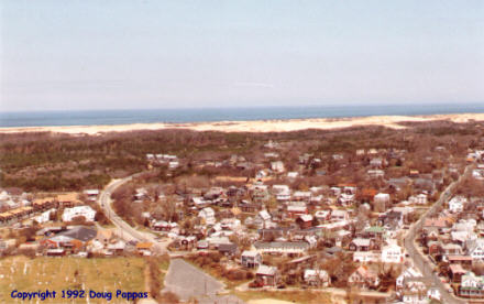
Throughout Provincetown and the nearby communities, mom 'n' pop motels and tourist seafood restaurants abutted the road. The Cape's done a good job of maintaining the indigenous tourist traps against the influx of franchised national outlets, though by the time I got to Wellfleet the outside world was very much in evidence. The tackiness quotient was much higher, too -- how about "Moby Dick's Restaurant, for a Whale of a Meal" in Wellfleet? As I should have expected, the more interesting places were further up the road, hence less accessible during tourist season. North of Wellfleet, the entire Atlantic shore of the Cape was part of Cape Cod National Seashore, which at least protected it from development; the beaches and dunes looked suitably impressive, though in this locale the water's probably too cold to swim in anytime before mid-July.
And of course, since this was Massachusetts, my drive across the mainland was plagued by the infamous Massachusetts traffic rotaries. What could be more fun than having two lanes of traffic merging, without a stop, into three lanes of traffic spinning counterclockwise, with those already in the circle entitled to the right-of-way even as they cut across in front of the entering vehicles to catch the next exit? The towns just inland of the Cape featured not just the expected seafood and lobster, but also all the wicker furniture you could ever want. (You, but certainly not me.) Each town's border was marked by a large Colonial-style sign by the side of the road, proudly proclaiming the year of the town's founding. One of these towns, Fall River, distinguished itself and maintained the Grand Army of the Republic theme by erecting monuments to its fallen soldiers in the small median strip.
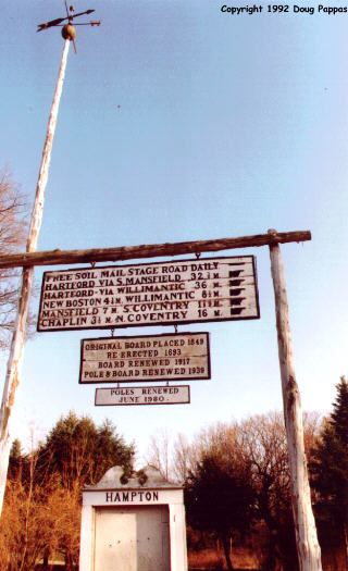
Didn't stop for anything in Rhode Island, which I passed through just as every office in the state was disgorging its workers. Once clear of Providence, though, 6 traverses a succession of small towns before crossing the Connecticut line. Almost at once I began driving through archetypal New England terrain for the first time: narrow, winding roads with trees overhanging the route and at least one picturesque old building in each town. Brooklyn, the first such town I encountered, added a small roadside picnic area and nearby babbling brook to the mix. Another town boasted an antiqued flagpole, weathervane and signboard, the originals of which dated to the 1840s.
Got to Hartford just in time to photograph the State Capitol and the city's ornate Civil War memorial arch, with the tallest building in town, the attractive, postmodern CitySpire, visible in the background. I'd hoped to reach at least Danbury before nightfall, to minimize tomorrow morning's backtracking, but no such luck -- the drive west will have to begin with a 90-minute detour to the northeast.
Go to the next day
Back to Old Road Trips menu
Back to ROADSIDEPHOTOS.COM home page