| |
Saturday, September 2, 1999...
Howdy from scenic Collinsville, Illinois, home of the World's Largest Catsup Bottle,
on Day 1 of my Route 66 trip.
No, that's not a misprint. No, I didn't re-send my May trip journal by mistake.
I'm driving Route 66 again because the forecast called for rain in South Dakota.
That makes sense, doesn't it?
Guess I should explain. In planning this trip, I had a hard time deciding between
a leisurely loop around the Upper Midwest, through the Rockies and back east,
or a Route 66/US 40 loop from Illinois to California and back. For either option,
the trip would start and end in Cincinnati so I could see my stepmother, who
suffered an incident of congestive heart failure about six weeks ago. She's
back at work now, but this isn't the year to skip that particular family obligation. From early this week, the Weather Channel long-range forecast showed days
of rain over the Dakotas and a clear weather along Route 66 -- an easy choice.
Even while driving 66 in the spring, I knew I was skipping some sights and
had missed others. I wouldn't be revisiting the route so soon, though, except that
I decided over the summer to reorganize my photo albums. Since this will
involve consolidating all of my Route 66 pictures in one place, it made sense
to fill in the gaps now and add everything at once, instead of doing it now and
then again after the next trip.
This time the trip will go faster: I'm skipping the
most tedious urban segments (bye-bye, Chicago and Los Angeles), avoiding
attractions I visited last time (if I never see the Precious Moments chapel again,
it'll be too soon), and following the Interstate past the dull stretches. Then
I'll drive north and return to Illinois via old US 40, again bypassing the slow spots.
Flew to Cincinnati last night -- my first visit to the Cincinnati airport since the
1970s, when I was sentenced to summers of Quality Time with my father and
stepmother. It's grown. So much, in fact, that my flight landed at a terminal
which isn't connected to anything except by shuttle bus. The Cincinnati airport
is actually in Kentucky, where generations of tobacco-chewing inbreds have
made the facilities safe for their kinfolk by banishing almost all text from the
navigational signs in favor of easy-to-understand symbols. Their airport design
could use a little work, too: shuttle buses make a sharp right turn immediately
before reaching the pickup area, rendering them invisible to prospective
passengers until the last possible moment, and anyone picking up a rental
car must drive a full loop past all of the airline terminals before being allowed
to exit.
My stepmother looked and sounded better than I had feared. She was
napping when I arrived -- a good thing, since we talked until 1 AM and she
had to get up at 5 AM for work. Since I'll be seeing her again next Saturday,
I opted not to do the same.
Was on the road by 8 AM, though, to drive from Cincinnati to St. Louis via
Chicago. Last time I had asked for a tape deck in the car and didn't get one;
this time I said nothing but got one. But as part of the fun is picking up the
local color, I left the radio on most of the time. Just past the Indiana line, while
being bombarded with billboards for the region's largest RV dealer, the
unfortunately-named Tom Raper, I found a call-in show for aging, hysterical
reactionaries demanding an end to the Federal Reserve system and America's withdrawal from the UN, followed by a station which seemed to play nothing
but black gospel music from the Forties and Fifties. Also ran across a roadside
rarity: a Stuckey's that hasn't been closed or converted to something else.
Traversed the industrial environs of Chicago on I-80 (where a billboard trumpeted: "WHO'S THE FATHER? 1-800-DNA-TEST"), before catching up to Route 66
in Joliet. Didn't feel like a real road trip, though, until I was dining at the
Launching Pad in Wilmington, beneath the benevolent eye of a 30' giant clad
in a space helmet and clutching a rocket. From there, despite my familiarity
with the route I found a number of things I had missed before: Braidwood's
Polka Dot Drive-In, Godley's replica Burma-Shave signs, a 1920s bridge in
Pontiac marked with the logo of Route 66's predecessor, State Route 4.
(By the way, Bob and Lisa, Amy lived one block off 66.)
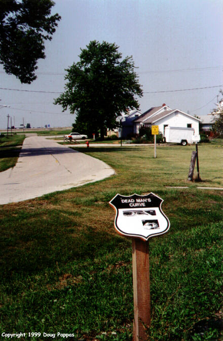
Stopped once again at the Route 66 Hall of Fame, conveniently located in
a lobby of the Dixie Truckers' Home, and photographed "Dead Man's Curve,"
an abrupt 90-degree bend in the original two-lane Route 66 at Towanda, IL.
"Towanda" is also (a) the name of a summer camp in Pennsylvania represented
by my firm, and (b) an Indian word meaning "place where we bury our dead."
Do the parents who entrust their offspring to our client know he's running
Camp Cemetery?
 I'm spending the night just outside St. Louis. Should be in eastern Oklahoma
by tomorrow night -- where, hopefully, Mother Nature won't throw any more
tornadoes my way.
I'm spending the night just outside St. Louis. Should be in eastern Oklahoma
by tomorrow night -- where, hopefully, Mother Nature won't throw any more
tornadoes my way.
Go to the next dayBack to NEWS FROM THE ROAD menuBack to ROADSIDEPHOTOS.COM home page
|