Greetings from Montpelier, Idaho, a dot on the map in the southeastern corner of the state. No, the Nazis aren't around here -- they're way up in the tip of the panhandle.
150 years ago, emigrants took more than two months to travel from Casper to the end of the trail near Portland. I'm doing it in three days. Anyone interested in the Trail should check out the two indispensable guides: The Oregon Trail Revisited and Maps of the Oregon Trail , both by Gregory M. Franzwa. (Greg subsequently branched out into early 20th century transportation history by organizing the modern Lincoln Highway Association, but that's another drive...)
The emigrants carried their own food. With 300 miles of driving and at least five miles of hiking before the next town of more than 500 people, so did I, securing a styrofoam cooler, ice, beverages, snacks, and the all-important sunscreen before setting off this morning. First stop: Independence Rock, one of the most famous Trail landmarks.
Half a mile long and rising almost 200 feet above the prairie, Independence Rock marked a natural campsite for the migrants. Thousands of them carved their names into its surface; hundreds of those signatures are still visible. Although signs warn modern visitors not to add to the graffiti, we're still allowed to climb on the Rock -- it's an easy hike, though the altitude of over 6,000 feet doesn't help.
A half-dozen miles down the road, the Mormons have established a visitor center at Martin's Cove, where an early winter killed more than 100 migrants in 1856. These impoverished Mormon converts, hauling their belongings along the trail in handcarts, were caught by a late October blizzard. (The Mormons followed the Trail to southwest Wyoming, but traveled apart from other groups: especially after founder Joseph Smith was dragged from jail and lynched by an angry mob in Illinois, they realized they were about as popular among other Americans as Satanist pedophiles are today.) From a modern footbridge over the Sweetwater River, the pilings from the 1850s bridge are visible below.
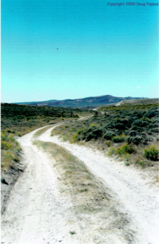
The Trail soon veers away from all modern roads, meandering for 40 miles toward the mining town of Atlantic City. The guidebook says that anyone who drives it without a high-clearance 4x4 is "certifiably insane," and notes further that in case of trouble, there's no cellular service in the area and CBs are unlikely to reach anyone who can help. I continued on to the easy route to Atlantic City, which only involves three miles of steep, winding gravel road.
Atlantic City, Wyoming is only slightly seedier than its New Jersey counterpart. In fact, some of the miners' shacks wouldn't look out of place a few blocks in from the Boardwalk. The town's most prominent business is a spectacular saloon, with metallic-silver facade, which would be a natural for beer commercials if there were a film crew within 500 miles. From Atlantic City, the road continues to South Pass City, a restored mining town with a surprising place in American history.
South Pass City was settled in 1867, following a gold strike. Two years later, its representative to the first Wyoming territorial legislature introduced the bill which made Wyoming the first jurisdiction in America to give women the right to vote. Two months later, the town received the nation's first female judge. But it was a mining town, after all -- the men didn't have time to waste on governing and most of the women in town were performing very un-judicial services. (The tour guide matter-of-factly notes that one of the saloons "doubled as a whorehouse.") A sign in the restored hotel nicely debunks romanticized images of the Old West, noting that only one guest room in the hotel had heat, while "guests in the other rooms used several blankets and probably shared their beds with strangers who, like themselves, may not have bathed in many days."
 A
dozen miles southwest of town, the Trail came to South Pass
itself, the eagerly-awaited crossing of the Continental Divide.
Incredibly, there's no modern marker at the site -- indeed,
the nearest paved road is three miles away. The guidebook
describes how to get there: turn left on an unmarked gravel road,
drive 2.8 miles, turn right on the unmarked original Trail, and
proceed for almost a mile over a surface so bad that it can only
safely be driven in a passenger car by keeping one wheel on the
crown between the eroded ruts, the other on the heavily vegetated
shoulder, and creeping along at 5 MPH. Otherwise, the guidebook
warns, "gnarled stumps of dead sage in the crown can wreak
havoc with hydraulic lines," or "concealed rocks in the
high crown can tear a gash in a transmission or oil pan."
A
dozen miles southwest of town, the Trail came to South Pass
itself, the eagerly-awaited crossing of the Continental Divide.
Incredibly, there's no modern marker at the site -- indeed,
the nearest paved road is three miles away. The guidebook
describes how to get there: turn left on an unmarked gravel road,
drive 2.8 miles, turn right on the unmarked original Trail, and
proceed for almost a mile over a surface so bad that it can only
safely be driven in a passenger car by keeping one wheel on the
crown between the eroded ruts, the other on the heavily vegetated
shoulder, and creeping along at 5 MPH. Otherwise, the guidebook
warns, "gnarled stumps of dead sage in the crown can wreak
havoc with hydraulic lines," or "concealed rocks in the
high crown can tear a gash in a transmission or oil pan."
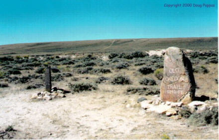
But this was HISTORY! "Damn the transmission, slow speed ahead!" I exclaimed, easing the car almost into a clump of sagebrush on the shoulder and apologizing in advance to my kidneys for the ride. It was every bit as bad as advertised. The actual crossing of the Divide is marked by two small stones, both placed by private citizens more than 75 years ago. Judging from the number and condition of tire tracks, I'd bet that in the average year, this site receives fewer visitors than the summit of Mt. Everest. Upon returning to pavement, I listened intently for a few seconds to be sure nothing had fallen off the car. Then I checked the rental car agreement: I wasn't supposed to be driving on any unpaved roads, let alone balancing atop wagon ruts. (Oops. Don't tell Alamo.)
 West
of the Divide, the Trail fragments along paths even a 4x4
can't follow. The trails converge again at Fort Bridger,
in southwestern Wyoming -- but when I got within a mile of the
fort and saw about 10 vehicles for every resident, with locals
offering $3.00 parking on their front lawns, I knew something was
up. Some type of festival had overrun the fort and its grounds,
on which dozens of temporary tepees had been erected for the
convenience of vendors. So much for that stop...
West
of the Divide, the Trail fragments along paths even a 4x4
can't follow. The trails converge again at Fort Bridger,
in southwestern Wyoming -- but when I got within a mile of the
fort and saw about 10 vehicles for every resident, with locals
offering $3.00 parking on their front lawns, I knew something was
up. Some type of festival had overrun the fort and its grounds,
on which dozens of temporary tepees had been erected for the
convenience of vendors. So much for that stop...With the Trail again inaccessible, I turned northwest, joining US 30 at Kemmerer (home of J.C. Penney's first store, as well as the Stock Exchange Bar and Liquor Locker, which figure prominently in the travel tales of my friends Steve O. and Bill M.) and following it across the Idaho border. Tomorrow I cross Idaho; Tuesday I push on to Oregon City. Stay tuned...
Go to the next day
Back to NEWS FROM THE ROAD menu
Back to ROADSIDEPHOTOS.COM home page