Oops, that's someone else's story. ĀMine began with a drive from Green River to Moab for breakfast and reprovisioning. ĀI was in no hurry -- today's first stop, Canyonlands National Park, was best enjoyed with the sun high enough to shorten the shadows. Ā
Canyonlands contains three separate units, divided by the Green and Colorado Rivers. ĀThe Maze, the furthest west, is inaccessible except by boat or 4WD vehicle. ĀI started the day in the Island in the Sky section and finished in The Needles, visiting Arches National Park in between. Ā
The Island in the Sky section includes the land between the Green and Colorado Rivers. ĀThe Colorado, which carved the Grand Canyon, does an equally impressive job here, though on a smaller scale. ĀWhile passenger cars are confined to a series of overlooks. several narrow dirt trails allow those in the proper vehicles to wind their way down to water level. ĀI was envious.
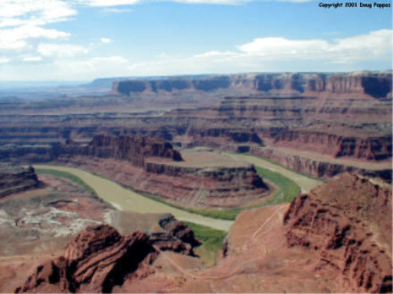 Surprisingly, the region's best view isn't in the national park, but in the adjacent Dead Horse Point State Park. ĀThe state park's main overlook offers a 270-degree view of the Colorado River and environs, including formations as impressive as any at the Grand Canyon. ĀAnd here, unlike at the Grand Canyon, you can almost always see the river...
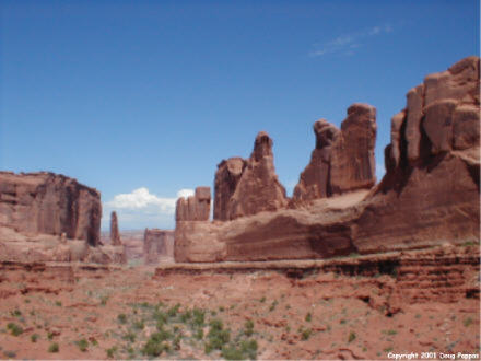 Even the access roads between Canyonlands and Arches offer more breathtaking scenery than the entire state of Nevada. ĀAt Arches, the focus shifts from water to wind: Āthese spectacular formations were primarily carved by gusts of air hitting soft sandstone. ĀDelicate Arch, the park's most famous (original name: Ā"Schoolmarm's Britches"), has often appeared on Utah license plates. ĀAnother highlight is Balanced Rock, where a 55' high, 3,500-ton boulder remains precariously balanced atop a pedestal made of faster-eroding rock. ĀOne of these years that sucker's going to fall...
Alas, the temperate weather of Yellowstone has been replaced by the heat and humidity of the desert. ĀAnyone who could corner the market on ice and cold beverages in Moab could retire within a month - as the only good-sized town in all of eastern Utah, it serves the needs of thousands of drivers, hikers, bikers, and boaters each day.
Before reaching The Needles section of Canyonlands, though, I confronted what may be the single ugliest tourist trap in America, Hole N" The Rock south of Moab. ĀMore than fifty years ago enterprising locals gouged out the base of an immense sandstone rock, turned it into living quarters and a gift shop, and began offering tours. ĀTo attract passing vehicles they used the rest of the rock as a canvas on which to paint "HOLE N" ĀTHE ROCK" in bright white letters several feet high. Ā(Yes, that double apostrophe after the N is correct...though God knows what it's intended to abbreviate.) ĀIf this double-pronged visual and punctuational assault weren't enough, the proprietors have covered the ground in front of the entrance with a wide variety of hideous lawn ornaments.
Like Arches and the northern section of Canyonlands, The Needles section involves a long one-way detour off US 191. ĀBut by the time I got there, the morning and early afternoon sun had been largely replaced by clouds...clouds that spawned occasional lightning. ĀSo much for detailed exploration of The Needles -- rain would render the dirt roads impassable, and the foot trails and overlooks were no place to stand during a thunderstorm. ĀSo I continued downt o Blanding, in the southeast corner of the state. ĀTomorrow night I'll be in St. George, in the extreme southwestern corner -- and as yet have no idea what route I'll take, or how many stops I'll make en route. ĀI'll sleep on it...starting right now...
Go to the next dayBack to NEWS FROM THE ROAD menuBack to ROADSIDEPHOTOS.COM home page