Started this installment of the Effects of Erosion Tour with a small park and ended with a very big one. I began the day with a quick swing through Natural Bridges National Monument, home to three natural bridges of varying ages. (Geological note: a "natural bridge" is originally carved by running water, while an "arch" results from other erosional forces like frost and seeping moisture.) Hiked down to the base of one of the bridges, and got 3/4 of the way down to another when I discovered that further progress would require descending a rickety-looking 15' ladder. No thanks, especially with nobody around in case I slipped and no hospital within 50 miles...
Then turned south along Utah Route 261, an innocuous-looking two-lane road which suddenly became one of the best of the trip. It descended practically down the face of a 500-foot cliff: suddenly the pavement ended and the road became gravel for three miles of steep (10%) switchbacks signed with a speed limit of 5 MPH. That was a bit excessive -- most of it could be comfortably traveled at 15 MPH. Not often I get the chance to go three times the speed limit...
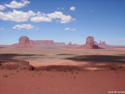
Just 200 yards north of the Arizona line came the turnoff for Monument Valley, a Navajo tribal park. The mesas here have been featured in dozens of Westerns, from the sublime (Stagecoach, The Searchers) to the ridiculous (The Trial of Billy Jack, the 1980 Legend of the Lone Ranger, starring the immortal Klinton Spilsbury). A 17-mile gravel road loops through the park; at many stops, local Navajo women sell silver jewelry.
South of the park, the only local radio station is KTNN, Voice of the Navajo Nation from Window Rock, Arizona. It broadcasts about half in English and half in Navajo, a language so unlike anything else that during World War II Navajo "code talkers" transmitted messages the Axis powers were never able to decode. (A museum honoring the code talkers is contained in, of all places, the Kayenta, Arizona Burger King.) A local cell-phone company was touting its service as perfect for those on the reservation who live in areas so remote that phone wires don't reach them.
After leaving Monument Valley, I had to drive almost due west to St. George -- but the way was blocked by a huge gash in the earth carved by the Colorado River. So long as I had to cross near the Grand Canyon, I figured that I might as well stop. The South Rim was closer, but from there to St. George would be a 350-mile loop along Route 66, across Hoover Dam and through Las Vegas, so I opted for the North Rim.
The rims of the Grand Canyon are just 10 miles apart by air, but over 200 miles apart by car. The South Rim gets about 80-90% of the visitors; the North Rim gets about 80% of the snow -- enough, in fact, to close the park from mid-October through early May. But this time of year the coolness of the 8,500' North Rim was a welcome relief.
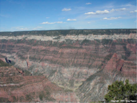
One of these years I'm going to raft through the Canyon, or at least hike to the bottom and back. The park newspaper reports that 40,000 people/year spend the night at the bottom of the Canyon -- there's a full-fledged hotel, Phantom Ranch, right along the water. A trip to the bottom is just about the only way to see the Colorado River, which is invisible from all but a few places along the rim.
Left the Canyon just as it was getting too dark to photograph, then had a three-hour drive along back roads to St. George. Tomorrow it's on to Zion National Park and Cedar Breaks National Monument...
Go to the next day
Back to NEWS FROM THE ROAD menu
Back to ROADSIDEPHOTOS.COM home page