Began the day by returning to Cedar Breaks, where I finally got some use out of the light jacket I had brought alojng. ĀCedar Breaks is almost two miles above sea level, along a road closed by snow six months of the year -- I once got into a snowball fight here on July 1. ĀAfter photographing the overlooks in the morning light, I continued on to Bryce Canyon.
Like Zion Canyon, Bryce has the makings of a traffic nightmare: Āa single road, 18 miles long, with occasional turnoffs and parking areas. ĀSo far at least, Bryce hasn't banned passenger cars. ĀInstead it tries to bribe visitors to take shuttle buses, offering $5 discounts off the park admission fee for those who do. ĀThe Bryce shuttle buses are perfect for hard-core hikers, too -- they can follow trails from one viewpoint to the next without having to double back .
But unlike Zion, where most of the action is in the canyon itself, at Bryce visitors travel along the rim. ĀThere's only one rim: ĀBryce is technically an amphitheater rather than a canyon, with all the viewpoints facing east. ĀThe park was named for 19th century settler Ebeneezer Bryce, who spent five years trying to farm here -- he described the canyon as "a hell of a place to lose a cow."
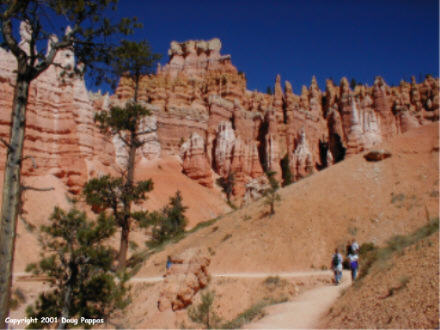 That's for sure. ĀBryce's dominant features are endless series of "hoodoos," vertical orange and white formations carved from the rock. ĀFrom a distance they resemble rows of soldiers standing at attention. ĀMile for mile, Bryce is the most photogenic place I've ever visited -- every angle of every viewpoint is unlike all the others, and unlike anything ever seen outside the park. ĀNumerous trails lead down among the hoodoos -- I hiked one of these trails, but a slightly sprained ankle (the result of sliding down a hill a little faster than I should have) put an end to the day's hiking. ĀAnyone interested in hiking or photography could easily spend a day and a half at Bryce.
From the park, I followed SR 12 north and east toward Capitol Reef National Park, the eighth and last national park of the trip. ĀEn route I passed Utah's Kodachrome Basin State Park, the only natural feature I know that bears the name of a commercial product. ĀThe state and federal governments may be missing a bet here: Āthink of the sponsoring and naming-rights opportunities! ĀI could have started the trip in Enron Yellowstone Park, driven the Goodyear Loop around the park, stopped at the Evian Upper Falls of the Yellowstone and Met Life Old Faithful, then departed for the Hooters Grand Tetons...
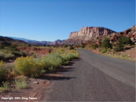
The 2-1/2 hour drive to Capitol Reef passes through the brand new Grand Staircase-Escalante National Monument, featuring still more spectacular scenery. ĀCapitol Reef itself is named for a domed formation resembling the U.S. Capitol, part of a giant wrinkle in the earth's crust called the Waterpocket Fold. ĀFrom overlooks and the park road, the cliffs on one side of the park seem to have been constructed on a 15-degree angle. ĀThe site also contains Indian petroglyphs and the remains of the pioneer Mormon settlement of Fruita, named for the trees that continue to provide fresh, wholesome snacks for park visitors.
 Left Capitol Reef at about 6:15, then followed back roads for 3-1/2 hours to my motel. ĀEn route I passed through numerous Mormon towns, immediately recognizable for their wide main streets, before reaching what may be the only motel in the state that doesn't have a Book of Mormon right next to the Gideon Bible. ĀOn to Salt Lake City in the morning...and home tomorrow afternoon! ĀI plan to sleep most of Sunday...
Go to the next dayBack to NEWS FROM THE ROAD menuBack to ROADSIDEPHOTOS.COM home page