The skies finally cleared, and I was able to do just about everything I had wanted to do. Started the day with a drive along the Historic Columbia River Highway, which along with Massachusetts' Mohawk Trail is one of the first roads designed primarily for scenery and pleasure driving. The HCRH opened for traffic in 1916; Sam Hill, of Stonehenge fame, was one of its biggest boosters.
The first eight or nine miles marked as the HCRH look like almost any other semi-rural street. Then the road veers toward the Columbia River Gorge and the fun begins. Several overlooks provide spectacular views of the gorge. The Vista House, constructed as a tourist center, is closed for repairs until next year, but when I pulled up this morning to enjoy the scenery from the overlook 700 feet above the Columbia, I was joined about about a dozen members of a local Model A Ford club, driving their antique vehicles along the HCRH.
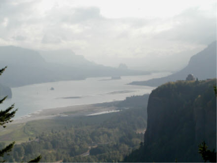
Then come the waterfalls. They're not on the Columbia River itself, but result from small streams flowing off the edge of the cliffs forming the Columbia River Gorge. Some can be viewed from the road; others, such as Bridalveil Falls, require a short hike. Best of all is Multnomah Falls, which is not only visible from the road but has its own exit/parking lot directly from I-84. Descending 620' in two jumps, Multnomah is the highest waterfall in the 48 contiguous states outside of Yosemite National Park.
After continuing another few miles on the last surviving drivable portion of the HCRH, I turned around and headed west. Before turning north to Mount St. Helens, I drove south to Oregon City and the End of the Oregon Trail Museum. Had planned to visit this museum a couple of years ago, when I drove the western half of the Trail, but got there after it had closed. I'm glad I got there, but I won't be going back again anytime soon.
From the parking lot, the End of the Oregon Trail Museum, located on a historically significant plot of land visited by thousands of migrants, looks like three oversized covered wagons. The architecture's the most surprising thing about the Museum, which tells the story of the Trail competently but unspectacularly -- and from my perspective, annoyingly, inasmuch as the first 50 minutes is a combination lecture-and-film that doesn't allow visitors to move at their own pace.
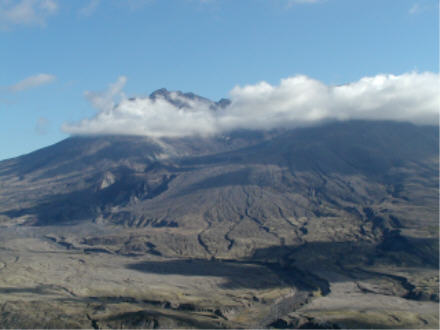
I then turned north toward Mount St. Helens. With three widely separated viewpoints located several hours' drive from one another, St. Helens can't be covered thoroughly in less than a full day. For now, I settled for the 50-mile-long spur route toward St. Helens from the northwest. I'll be back...
Mount St. Helens stands 8,366' tall. Until May 18, 1980, it stood 9,377' tall. That morning the top of the mountain and one entire side essentially flowed northwest, following an explosive eruption that destroyed 150 miles of forest and scattered ash as far as Montana. The viewpoints I visited were on the side where the lava flowed, where trees and rivers have returned to areas laid barren by the eruption. Visitor centers provide before-and-after images.
At 5:00 tonight I was standing at a viewpoint 52 miles from I-5, which in turn was almost 50 miles north of the Oregon line. My motel room was in southern Oregon. In other words, it was time for the other kind of road trip driving: a long nighttime sprint down the Interstate. In the morning, I'll head over to the northern California coast and at least drive the California part of US 101. Washington and Oregon will have to wait for another trip... Later!
Go to the next day
Back to NEWS FROM THE ROAD menu
Back to ROADSIDEPHOTOS.COM home page