Wednesday, June 24, 1992...
The first of two long days on the road. I was timing this trip to reach St. Louis on Thursday night for the annual Society for American Baseball Research convention, but had stupidly failed to focus on the fact that St. Louis is 2/3 of the way to the East Coast, not "somewhere in the middle."
The morning's first stop was Black Canyon of the Gunnison N.M., where the long-standing channel of a fast, steep river was intruded upon by very dense, dark rock from the earth's crust. At one spot the canyon's 1800' deep but only 1100' across: not as photogenic as some other formations just because the rock is so dark, but I heard one man say he liked it better than the Grand Canyon. I wouldn't go that far, but...
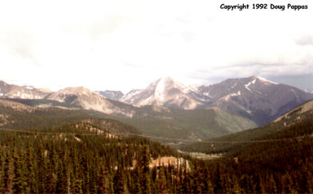
I continued southeast across Colorado, soon to be joined by hundreds of cyclists participating in a multi-day journey around the state. We climbed 11,312' Monarch Pass together, continuing down the other side to Salida. They stopped for the day, while I continued on to Canon City. The drive between Salida and Canon City follows the channel of the Arkansas River, which would have made for some lovely pictures if the day hadn't been overcast and drizzly. Eight miles west of town I turned for Royal Gorge, one of my old favorites. I think they've changed the pricing system; it's now $8.50/adult to enter the grounds, but this includes the bridge, tram ride, inclined railway to the base, and a few other attractions. I crossed the rickety wooden planks 1,053' above the Arkansas, then walked back on foot. The day was nasty enough I wasn't going to get any photos better than the ones I already had, so I decided to take the inclined railway because it's the only way I hadn't seen the bridge before.
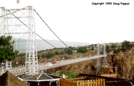
The two 30-passenger cars work like the ones on the Chattanooga inclined railway, counterbalancing each other on a single cable. Each compartment stands from one to three people, with a roof overhead but open space directly in front to allow for photos. From the bottom, the bridge looks even tinier and more rickety than from above; I also got a great view of some river-runners passing by in their rafts. It began raining in earnest on the tram ride up, which allowed me to experience the rare thrill of running across the bridge in a thunderstorm, with 40-MPH winds buffeting me and the couple of cars making the crossing.
After this experience, I concentrated on making time. Not that there was much to see anyhow; Canon City's Skyline Drive is fun, but not in a storm. Once past Pueblo the scenery opened up into agricultural land; with both heat and abundant water from thunderstorms and snow runoff, the area around Rocky Ford is a major cantaloupe producer. I chugged along to the Garden City, Kansas, arriving only to hear the motel desk clerk alert me that if they had a tornado warning, the safest place would be on the first floor. Fortunately we only got thunderstorms...
Go to the next dayBack to Old Road Trips menuBack to ROADSIDEPHOTOS.COM home page